
India recorded around 16 per cent more rainfall than normal in August, with rainfall over Northwest India recorded at 253.9 mm, the second highest in August since 2001, the India Meteorological Department (IMD) said on Saturday.

The Mungeshpur weather station recorded a high of 48.8 degrees Celsius, eight notches above the normal. It recorded a minimum temperature of 27.6 degrees Celsius, a notch above the season's average.

The unrelenting heatwave sweeping large parts of the country has claimed at least 110 lives and left over 40,000 people grappling with suspected heatstroke between March 1 and June 18 this year, health ministry sources said on Thursday.

The Southwest Monsoon is set to arrive early with the Andaman and Nicobar Islands expected to receive first seasonal showers on May 15, the weather office said on Thursday.


The country also reported 1,750 deaths due to extreme weather events such as floods, cyclonic storms, heavy rain, landslides, lightning, among others, during the year, it said.

India has received 20 per cent less rainfall since the start of the monsoon period on June 1, with the rain-bearing system making no significant progress between June 12 and 18, according to the India Meteorological Department (IMD).

Heavy rain in the first week of July compensated for the shortfall but caused flooding in many northeastern states.

India experienced its second-hottest quarter from June to August this year since 1970, with over one-third of the country's population enduring at least seven days of dangerous heat, according to a new report by a United States-based group of climate scientists and communicators.

Satellite imagery showed a layer of dense fog extending from Punjab and north Rajasthan to the northeast. Patches of fog were also visible along the east coast.

Prime Minister Narendra Modi on Monday chaired a high-level meeting to review preparedness for the hot weather condition in the upcoming summer season and called for preparing separate awareness material for different stakeholders like common citizens, medical professionals, local body authorities and disaster response teams.

As Cyclone Dana barrels toward the coasts of Odisha, threatening to impact nearly half of the state's population, the government is racing against time to execute a massive evacuation plan aimed at relocating about 10 lakh people in several coastal districts to safety. In West Bengal, the cyclone is set to bring heavy rainfall in several southern West Bengal districts, including Kolkata, the India Meteorological Department (IMD) has said.

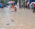
Villpuram district in north Tamil Nadu continued to reel under unprecedented flooding on Monday following extremely heavy rainfall, virtually blocking access to villages and residential colonies as bridges and roads overflowed, inundating huge acreage of standing crops and leaving passengers stranded as rail and road traffic was hit.

Rijiju, who was removed as law minister on Thursday, refused to answer questions about his previous ministry contending that they were no longer relevant and that he looked forward to serve in the Earth Sciences Ministry.

The city's 24-hour Air Quality Index, recorded at 4 pm every day, stood at 418, up from 334 the previous day, and it may trigger stringent restrictions under the third stage of the graded response action plan to mitigate hazardous conditions.

In view of the widespread rains and 'red alert' for extremely heavy showers issued by the India Meteorological Department (IMD) for several districts, control rooms are working round the clock to monitor the situation and help stranded people, he said.

The India meteorological department on Monday issued an 'orange alert' for Mumbai and Thane signalling very heavy rainfall till June 21.

The deep depression in the Bay of Bengal is likely to intensify further into a cyclonic storm by late Tuesday night, the IMD said.

Western Railway stated that local train services were running normally on Monday morning, however, commuters claimed trains were running late by 5 to 10 minutes.
Flight operations at Chhatrapati Shivaji Maharaj International Airport were suspended twice for a brief period due to inclement weather and low visibility, a source said.

Heatwave conditions are expected over northwest India during the next five days, with Punjab, Haryana, Rajasthan and Delhi predicted to bear the maximum impact, the India Meteorological Department (IMD) said on Thursday.

"This year, the Southwest Monsoon is likely to set over Kerala on May 31 with a model error of four days," the India meteorological department said on Wednesday.

Mercury hovered around 40 degrees Celsius in large parts of the country on Monday as the Indian meteorological department predicted heat wave conditions in parts of east India over the next four days and the northwest region over the next two days.

The very severe cyclonic storm was located over the east-central Arabian Sea located 840-kilometer west-southwest of Goa and 870 km west-southwest of Mumbai at 11.30 pm on June 8, the IMD said.

India is likely to see above-normal rainfall in the four-month monsoon season (June to September) with cumulative rainfall rainfall estimated at 106 percent of the long-period average (87 cm), he said.

>Bihar (18 days) has the most number of heatwave days in 2023, followed by Andhra Pradesh (15 days), Odisha (15 days), Jharkhand (13 days), West Bengal (8 days) and Tamil Nadu (6 days).

The Mumbai civic body and police have advised all people in the city and surrounding areas to stay indoors as much as possible.

In a notice, IMD said, 'VSCS BIPARJOY over east-central Arabian Sea, lay centred at 0530hrs IST of 08th June, near lat 13.9N & long 66.0E, about 860km west-southwest of Goa, 910km southwest of Mumbai, would intensify further & move north-northwestwards.'

On May 15, the weather office had announced the onset of monsoon over Kerala by May 31.

After making landfall near Puducherry on November 30, Cyclone Fengal weakened on Sunday, but torrential downpour under its influence paralysed the union territory, with the Army stepping in to evacuate stranded persons in inundated streets.

Andhra Pradesh Chief Minister N Chandrababu Naidu and his Telangana counterpart Revanth Reddy visited some inundated areas in their respective territories.
As Kerala battles severe heat, the meteorological department has issued a maximum temperature warning for 12 districts for the upcoming five days.

The India meteorological department (IMD) on Wednesday evening issued a red alert for Mumbai and its neighbouring districts, predicting "extremely heavy rainfall".

Light to moderate rain in many areas with heavy rain at isolated places is likely to occur in West Bengal's coastal districts of North 24 Parganas, South 24 Parganas and Purba Medinipur.

June rainfall accounts for 15 percent of the total precipitation of 87 cm recorded during the four-month monsoon season in the country.

Mohapatra said there is a 40 per cent chance of a normal rainfall, 22 per cent above normal, 12 per cent excess and 18 per cent below normal.

The administration is geared up for more showers as the India meteorological department has warned of heavy to very heavy rains with isolated extremely heavy rains in several districts of the state till Thursday morning.

The rains after arriving over Kerala will quickly cover Tamil Nadu and Karnataka, but then might slacken a bit, which could delay its arrival over Northwest India.

The India Meteorological Department's (IMD) regional centre for Mumbai has issued a 'yellow alert' for next three days, predicting heavy to very heavy rainfall at isolated places.

The rains could lead to a rise in the water levels of the Yamuna, which has been flowing above the danger mark of 205.33 metres for days now.